Long-Range Forecast – January 15

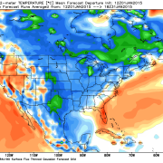
Flurries, snow showers, and freezing drizzle provided a little weather excitement (and headaches) on Thursday, but it certainly was not the big snow event that snow-lovers in Southern New England are yearning for. At the midway point of the winter, there has only been about 6″ of snow in the Providence area. However, the pattern for the first half of January has been cold, and there are strong indications that it will stay that way for the last ten days of the month. The big difference will be the storm track shifts south of Southern New England.

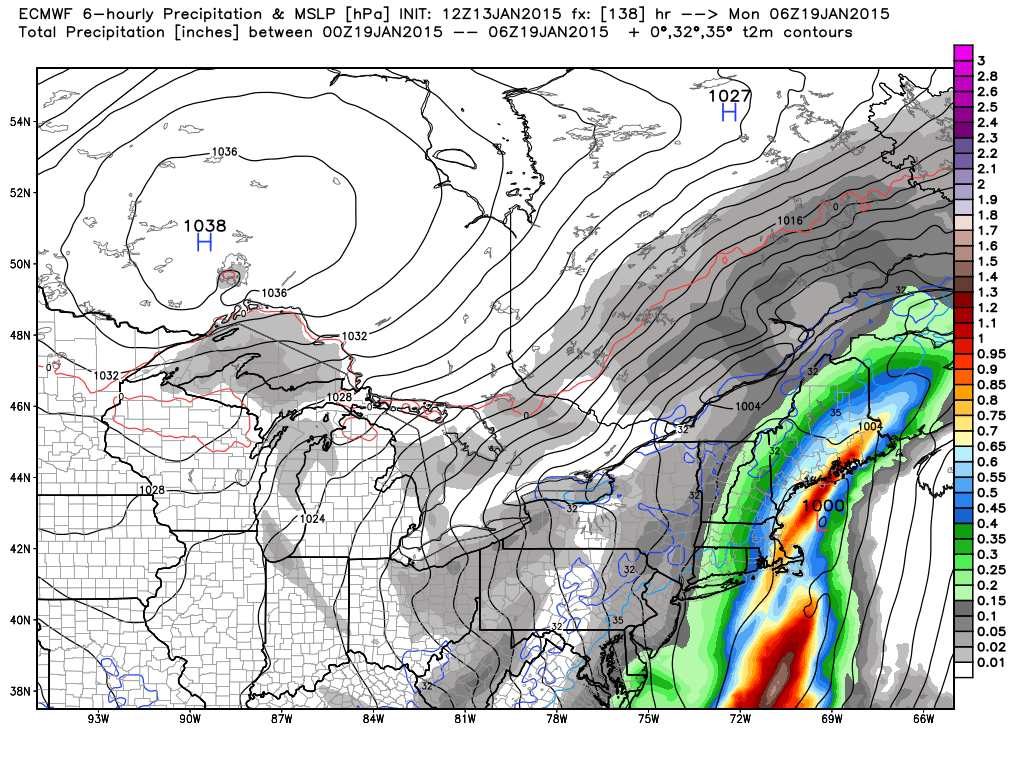
So far this winter, we have gone from cold/dry stretches to brief warm-ups when the storms track over or west of Southern New England. It was a wet December and after Sunday’s storm we’ll likely be on track for at least near normal precipitation in January. But, of course, there is a big lack of snow. For it to get snowy, the storm track needs to shift to south of Southern New England, giving a chance for northeast winds to lock in the cold air. So, if the storm track is shifting south, then you must think it’s going to get snowy, but that is not always the case. If the track is too far south, and the trough at 500mb positively tilted, then the storms are likely to miss Southern New England to the south as they head out to sea. While that looks like the case for most of next week, I think there is a decent chance that we’ll get into a snowier pattern in late January and early February. The longer range models are occasionally showing storms that have a wintry look in the Northeastern United States in the 10-15 day timeframe. That has not been the case for most of the winter.

Long-Range Forecast – January 13

We are close to the midway point of meteorological winter, and the snow-lovers in Southern New England have a lot to moan and groan about. There have only been 5.6″ of snow in the Providence area since November. That’s only 40% of normal, and that number will shrink in the coming days with no chance of accumulating snow into the weekend. The last time there was less than 20″ of snow in a winter in the Providence area was 2011-2012, when there was 17.8″. There was 15.1″ in 2006-2007. The all-time low was 1979-80 when there was only 9.7″ for the winter. While it only takes one storm to change the snow fortunes from “historically low” to just “lower than normal”, this winter has been a dud so far.

So, is there any chance of that big snowstorm in the next couple of weeks? The pattern does not look extremely promising for that to happen, but it will likely not be a completely boring pattern, either. It will probably not be as cold as the first two weeks of the month, but I don’t expect a blowtorch pattern to develop in the Northeast. The first shot at precipitation is on Sunday into Monday, and it looks like rain. If current trends are correct, it will be soggy for the AFC Championship game Sunday evening in Foxboro.

Computer models are trending toward a rain storm late in the weekend

Computer models are trending toward a rain storm late in the weekend

Looking ahead to next week, there will likely be another cold area of high pressure (fair weather) early in the week, followed by a frontal system that could bring rain/snow showers in the mid workweek. Later in the week, a bigger system may move out of the Southeast and head for the Northeast. It does not look like it would be an exclusively snow event, but that’s no surprise given the prevailing storm track this weekend. The 12-16 day timeframe continues to look fairly active, and seasonably cold, so that means there is at least a chance of some snow in that period.

2015-01-13-Headlines

Long-Range Forecast – January 5

The coldest weather since early last January is heading for Southern New England this week. The temperature will flirt with zero on Thursday morning, and wind chills will be -10 to -20. For the most part, the cold weather will not be accompanied by snow. Flurries and snow showers are possible on Tuesday, but it will not amount to more than a coating – at worst. Another clipper may bring up to 2″ of snow on Friday, but that does not look like a huge deal, either. In the early to middle part of next week there could be a system that comes out of the Southern states carrying more moisture, but it’s unclear how far north it will get, and, right now, it looks like it will mainly stay south of Southern New England.

The overall trend through the middle of the month is for cold and dry weather to persist in Southern New England. There may be snow on the ground, but it will likely not be deep, with no big storms ahead for the next week. With cold air around, the snow outlook can change quickly if a storm gets cranking, so, we’re hesitant to say that there definitely will not be a moderate or major storm between January 12-19, but, right now, it does not look too promising for a big one. A week or two ago we said we were leery of the cold/dry to warm/wet pattern this winter, and, so far, that has been the case. It was a cold end to 2014 and cool start to the New Year, but when the storm arrived it brought 1″+ of precipitation and only 1-2″ of snow.

See the headlines and video below.

Long-Range Forecast – January 1

2014 is in the books as 0.7 degrees cooler than normal in the Providence area. The first few days of 2015 will follow suit with colder than normal weather into the weekend, but a storm arriving Saturday night will be mainly rain with a surge of milder air likely on Sunday. The warmth will not stay for long, and by Monday the highs will be back to the upper 30s – not far from normal. It will be seasonably cold with the chance of light snow or flurries in the midweek as an Alberta Clipper passes by. The best chance of snow is Tuesday night into early Wednesday.

After the Clipper departs, there will be an Arctic blast that brings the coldest weather of the season so far, and possibly the coldest we’ll see all winter. If the full brunt of the Arctic air hits Southern New England, the temperature may nosedive to zero in some spots Thursday or Friday morning. Highs may not make it out of the teens. It will be dry into next weekend.

Overall, January looks like a chilly and active month of weather. It may not be as cold after January 10, but the storm track looks pretty active, so snow chances exist through mid-month. We’re still somewhat concerned about a dry/cold to wet/mild pattern like we’ll see with this weekend’s storm, but the overall storm track looks a little further south (colder) after the big Arctic outbreak at the end of next week.

  • Temperature: Below normal next two weeks
  • Precipitation: Near normal next two weeks
  • Snow: Below normal next two weeks
The temperature spikes with the weekend storm, but it's back to the ice box next week

The temperature spikes with the weekend storm, but it’s back to the ice box next week

The EPS ensembles do not have a lot of snow in the next ten days. Notice how there is pretty good agreement on a minor system in the middle of next week

The EPS ensembles do not have a lot of snow in the next ten days. Notice how there is pretty good agreement on a minor system in the middle of next week

EPS agreement on big cold shot late next week

EPS agreement on big cold shot mid to late next week

Days 10-15 look a lot milder on the EPS. Not sure if it will be extremely mild, and there should be a fairly active storm track in the middle of the month

Days 10-15 look a lot milder on the EPS. Not sure if it will be extremely mild, and there should be a fairly active storm track in the middle of the month

GFS also showing a slight warm-up in days 10-15

GFS also showing a slight warm-up in days 10-15

CFS v2 has a cool to cold January for most of the country

CFS v2 has a cool to cold January for most of the country

CFS v2 is also stormy with above normal precipitation in January

CFS v2 is also stormy with above normal precipitation in January


Long-Range Forecast – December 29

The unseasonably mld stretch of weather is gradually ending in Southern New England. It will be near or slightly below normal to round out 2014 and begin 2015 this week. It will also be dry into the weekend. There is little doubt that the overall weather pattern looks colder in the next couple of weeks, but the devil is in the details of whether it will be cold and dry or cold and snowy. The first challenge is with a weather system arriving late this weekend. It’s still possible that there will be snow or mixed precipitation from that system, even though most models are mild with mainly or all rain.

Next week there will be another huge area of high pressure bringing more cold weather to the Western United States that bleeds east during the week. The boundary between the cold weather and relatively warm weather in the Southeastern United States may prove to be fertile breeding grounds for inclement weather. While this pattern does not promise snow, there is certainly potential for it. As the weather gets more active, we’ll be adding Computer Model Trends updates when storms threaten. So, even though the day to day weather is not very predictable 5+ days out in this pattern, we’ll be doing our best to let you know what’s on the way.

Long-Range Forecast – December 26

It is no secret that snow has been hard to come by so far this winter. December is running a few degrees warmer than normal, and all the big storms have been all rain. So far this month, there has only been 0.9″ of snow at TF Green Airport. The normal snowfall for the month to date is 7.1″. There may not be any snow for the rest of the month, and that will place this December as the 16th least snowiest since 1904. Although it’s a limited sample size, a non-snowy December does not bode well for snow for the rest of the winter. The last time there was less than an inch of snow in December was in 2011, and the winter snow total was only 17.8″ – about half the normal amount.

Of the 15 Decembers with less than 1″ of snow in Providence, only two have been in winters where the seasonal snow total was above normal. In 1934-35 there was 35.5″ of snow, and in 1957-58 there was 38.9″ of snow. The normal snow total for Providence is just under 35″. 10 out of the 15 winters with non-snowy Decembers have had less than 18″ of snow for the season. So, for snow-lovers, this winter is not looking good based on observations from the past 110 years. It’s also not looking good for our winter seasonal forecast of 100-150% of the normal snow in the Providence area.

However, just because the odds are stacked against a shift to a snowy pattern, that does not mean it cannot happen. There are signs that the storm track will remain active in January, and a couple of big storms could put a serious dent in the snow deficit. It’s unlikely, though, that a big snowstorm is coming in the next 10-14 days. It will turn colder next week, but the pattern will likely be dry through the New Year into next weekend. There is a good chance of a storm next weekend, but it looks like it will bring mainly or all rain to Southeastern New England. After next weekend, the pattern is uncertain. I think there is a good chance of more stormy weather between January 6-10, and there may be enough cold air around for at least some wintry precipitation.

Long-Range Forecast – December 23

Where’s winter? That’s the question a lot of New Englanders are asking these days. December has been slightly mild and very wet to date. With another soaker on the way, this may become a top-10 wettest December on record in the Providence area where the records date back to 1904. It will also be unseasonably mild for a few days, and that should push this month from “slightly mild” to “very mild” by the end of the weekend.

There are still some signs that the pattern will change late in the month and early next year, but it does not look like as much of a slam dunk as I thought it would be. It will be colder next week, and our first shot at snow is early in the week. Very cold weather will move into the western United States, and it will slowly slide east. There may be opportunities for snow, but there is nothing glaring that suggests it’s imminent. There has not been a lot of run to run consistency among the computer models in the 8-15 day range. Sometimes it looks like we’re in for a rather snowy 8-10 days, other times it’s cold and quiet, and there are some runs where it’s not even that cold!

I will be watching this pattern evolve over the next few days, and the next Long Range Forecast will be on Friday. Have a Merry Christmas!

Long-Range Forecast – December 18

It looks like Santa will be riding his sleigh on a strong southeasterly wind Christmas Eve in Southeastern New England. A strong storm will cut west of New England, and we’ll be on the mild side of it with rain heavy at times, and the chance of a thunderstorm Wednesday afternoon and evening. The rain may end by late in the evening, and it will mostly likely be long gone by Christmas morning. The temperature will spike into the 50s to low 60s due to the strong southeasterly winds which may cause damage – especially near the coast.

It will turn cooler on Christmas, but we do not expect it to be very cold. Highs will be in the 40s. There will be a gusty westerly wind on Thursday. Depending on the track of the storm, there could be snow showers in Northern New England, but it will most likely stay dry in Southern New England.

The stormy pattern may yield another rainmaker into next weekend. While it’s relatively mild in the Eastern United States, it will be turning much colder out West. The cold weather will gradually move east late in the year and into the new year. At this point, it looks like it could get here by New Year’s Eve. Eventually, as the pattern evolves, there will be snow threats, but that may not happen until around or just after the New Year.

Overall, we’re looking at December going in the books as mild, wet, and possibly among the least snowiest on record in the Providence area. For snow lovers, it looks like there is hope for a different pattern change in early January.

Long-Range Forecast – December 17

At the midway point, December 2014 is running near the normal temperature in Southern New England. It has been quite wet, with more than normal monthly precipitation falling in the first 10 days of the month. The pattern has quieted in the last week, but it looks like the action could pick up as we hit the last 10 days.

There will be a week system coming through in the midweek that will bring rain showers Tuesday night into Wednesday morning. Wednesday afternoon looks mild, with highs in the upper 40s. More quiet and seasonably cool weather is likely from Thursday into the weekend.

We are watching the potential for a storm late in the weekend. While it’s still possible that we will get hit, we’re beginning to think this one may mostly miss Southern New England, with just some snow showers ahead for Sunday. The trend over the past couple of days has been for a “flatter” system that slides out to sea south of Southern New England. That helps to keep the cold air in place, but the heavy precipitation does not make it into Rhode Island or Southeastern Massachusetts. It’s still several days away, so there could be further forecast changes.

Looking past the weekend, there is a pretty good chance of a storm around Christmas. Right now, it looks like Christmas Eve is the best bet for precipitation. Unfortunately, for those hoping for a white Christmas, the early projection for the storm is for it to draw in enough mild air for rain in Southeastern New England. Once again, there is a lot of uncertainty with such a specific forecast that is 9-10 days out, and there could be changes.

It seems that we’re in transitional phase over the next 10-14 days to a colder pattern. However, the prevailing storm track between now and then may not be favorable for a lot of snow in Southern New England. The pattern will likely yield another storm before or around the New Year.

Based on the active pattern, it’s possible this December will be among the top 10 wettest in the past 80 years in Southeastern New England. However, it will likely not be among the snowiest – in fact, if the weekend storm does not materialize, it could be among the least snowiest. So far this month, there has only been a trace of snow in the Providence area. It would be interesting to have such a wet month without much snow when the temperature pattern is not that much above normal.

HEADLINES

– Active storm track last 10 days of month – no snow guarantees
– Pattern trends colder late in the month
– Above normal precipitation next two weeks
– Near normal temperature next two weeks

Sorry about the lack of video and graphics in this update. Unfortunately, my workhorse Macbook Pro is on life support after suffering from a common problem that Apple does not consider to be a “known issue”. I’m off to the Apple store to get it looked at.


Long-Range Forecast – December 11

A slow-moving storm will ease away from Southern New England over the weekend, and high pressure will move in from the west. The weather will stay quiet until at least the middle of next week before a disturbance approaches. At this point, we’re not expecting a major impact from it in Southern New England. It looks like rain/snow showers in the midweek.

The overall pattern favors near normal temperatures and a mainly dry stretch through most of the next week. We are expecting the southern branch of the jet stream to become active in late-December, and that could lead to snow and/or rain threats every few days for the last ten days of the month. A white Christmas is not off the table yet!