Long-Range Forecast – August 29

We are heading into the Labor Day weekend and September with a warmer than normal weather pattern setting up in the Eastern United States. It’s a flip from the relatively cool weather that has been around most of the time for the past couple of months. The weather has been dry, as expected, for the last two weeks, and the pattern does not look very wet into mid September.

Highs will easily be in the 80s inland most of next week, and a 90° day or two cannot be ruled out through mid-September. It will also be warmer than normal at night, and this does not look like the September where you want to take the air conditioner out of the window early in the month.


2014-08-29-headlines

Long-Range Forecast – August 21

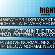
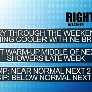
We are 20 days into August and there has only been one day, August 6  (+3°), more than 1° above normal. And, lately, there have not been any “warm” days. The past 10 days have been at or cooler than normal in the Providence area. We’ll keep the streak going into, and probably through, the weekend. The best, and possibly only, chance of widespread showers in RI and SE MA through most of next week is Friday morning. There will be increasing sunshine during the weekend, and it will gradually get warmer early next week.
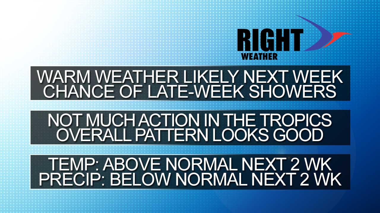
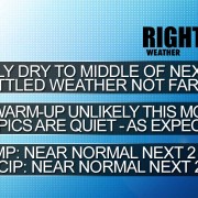
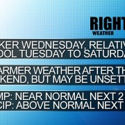
By the middle of next week, it will be at or warmer than normal for a few days. A cold front will bring the threat of a few showers late in the workweek or early in the Labor Day weekend. The front looks progressive, and another area of high pressure will move in from central Canada bringing more fair and seasonable weather.

The disturbance in the tropics has moved well north of the computer model consensus from a couple of days ago. Per the NHC, it has a 50-70% chance of becoming a tropical storm in the next 2-5 days. If Cristobal forms, the odds favor it passing east of Florida and moving out to sea, but a track farther south into the Gulf of Mexico is not completely off the table at this point. In any event, it’s no imminent threat to land.

2014-08-21-headlines


Long-Range Forecast – August 19

Tuesday morning was the coolest in nearly two months in the Providence area. It’s just one of many signs that the summer of 2014 is heading up the 15th fairway with just a few holes left. This August has been cool in Southern New England, and the outlook for the next week is for more cooler-than-normal weather through this weekend. It will be mainly dry, but not as beautiful over the weekend as it is in the middle of this week. Highs may struggle to get above the low 70s on Saturday and Sunday with some clouds and a fresh northeast breeze.

There is a brief opportunity for a warm-up early next week. Monday may make it to the mid 70s, and low 80s are possible Tuesday and Wednesday before a front comes through. It will not be hot and humid, but highs may make it into the low to mid 80s inland – a bit warmer than normal for late-August. The next best chance of rain is not until the middle to end of next workweek. It looks like scattered showers with a cold front. The very early outlook for Labor Day weekend is for a warm start and a cooler finish, with the chance of showers in the middle.
There are a few signs that the tropics are waking up. A disturbance in the Atlantic may take the low road through the Caribbean and make it into the Gulf of Mexico next week. A more likely scenario has it dissipating near South America because it is so far south. We’ll be watching closely to see if anything else gets cooking.

[signoff]

Long-Range Forecast – August 15

We are halfway through August, and the month is running about 2° cooler than normal in Southeastern New England. It was dry for a while, but Wednesday’s rainfall more than made up for the deficit in many spots, including the Providence area.

The first Long-Range Forecast of the week highlighted the potential for warm weather late in August. Now, it looks like the warmth will not be too impressive in the Northeast, and there are signs that it could be near or even slightly below normal. The bottom-line is more 90° heat seems unlikely, and the high temperature for the year in Providence may wind up being a relatively low 91°, with only three days reaching 90. That’s a far cry from last year, but something we were expecting in the seasonal outlook.

Unsettled weather will not be far from Southern New England in the next couple of weeks. At this point, it looks like high pressure over the Northeast and Eastern Canada will keep the rain away most of the time. If there is going to be a warm-up, it looks like it will happen late in the month, but, there has been a recent computer model trend where the warmth is there in days 10-15, but as those days near, it disappears.

Long-Range Forecast – August 12

The weather this week will be marred by a super soaker Wednesday. Before then it will be seasonable, and afterwards it will be a bit on the cool side Thursday into Saturday. The weather pattern is showing hints of heat in the last two weeks of August, but there are also signs that the weather will be unsettled from time to time. At this point, we are leaning toward a warmer than normal weather pattern for the end August, although it’s uncertain as to whether the warmth will come primarily at night in an unsettled pattern or during the day and night with some “dog days” weather. Even though it goes against the grain of this summer, I think we could have a few mid to upper 80s or even low 90s late this month.

This time of the year, we have to keep our eye on the tropics. The National Hurricane Center was looking at a disturbance in the eastern Atlantic Ocean, but it is unlikely to develop into a tropical system.

Long-Range Forecast – July 31

We are not looking at any major changes to this summer’s weather pattern in the next couple of weeks. There is still no sign of extreme heat, and, most days, it should be seasonable and dry. If Tropical Storm Bertha forms in the Caribbean as expected, it will likely move north of the Bahamas then curve out to sea. It’s worth watching just in case it does not get picked up and swept out to sea by the jet stream. If it has a chance to stall off the coast, then it may play a role in our weather at the end of next week, but that is an unlikely scenario.

There is a threat of showers from Saturday through Monday, with the best chance of rain on Saturday into early Sunday. Even at this point, there is still a lot of uncertainty with the weekend forecast. The best chance of rain Monday afternoon is away from the coast. Dry weather is expected through the middle of next week. Looking way down the road, the end of next week may get unsettled again. After several gorgeous weekends to start the summer, the weather has become a little dicey for the past couple of weekends, and the early outlook for next weekend is similar. Check out the video for more.

Long-Range Forecast – July 28

A dip in the jet stream (trough) will persist over the Eastern United States for the next couple of weeks. The resulting weather for Southern New England will be pleasant most of the time. There is no extreme heat ahead, and we may not make it above 85° very often. Most days should feature highs in the upper 70s to low 80s. There is also not likely to be too much humidity, either. Lows will be relatively comfortable, and we should continue to save money by not using the air conditioning as often as we had to last year – and in most summers.

The tropics may come to life as a disturbance in the Atlantic Ocean develops into Bertha. If the disturbance intensifies into a tropical storm or hurricane, it will most likely stay well off the Eastern Seaboard in the middle of next week.