Long-Range Forecast – December 29

The unseasonably mld stretch of weather is gradually ending in Southern New England. It will be near or slightly below normal to round out 2014 and begin 2015 this week. It will also be dry into the weekend. There is little doubt that the overall weather pattern looks colder in the next couple of weeks, but the devil is in the details of whether it will be cold and dry or cold and snowy. The first challenge is with a weather system arriving late this weekend. It’s still possible that there will be snow or mixed precipitation from that system, even though most models are mild with mainly or all rain.

Next week there will be another huge area of high pressure bringing more cold weather to the Western United States that bleeds east during the week. The boundary between the cold weather and relatively warm weather in the Southeastern United States may prove to be fertile breeding grounds for inclement weather. While this pattern does not promise snow, there is certainly potential for it. As the weather gets more active, we’ll be adding Computer Model Trends updates when storms threaten. So, even though the day to day weather is not very predictable 5+ days out in this pattern, we’ll be doing our best to let you know what’s on the way.

Long-Range Forecast – December 26

It is no secret that snow has been hard to come by so far this winter. December is running a few degrees warmer than normal, and all the big storms have been all rain. So far this month, there has only been 0.9″ of snow at TF Green Airport. The normal snowfall for the month to date is 7.1″. There may not be any snow for the rest of the month, and that will place this December as the 16th least snowiest since 1904. Although it’s a limited sample size, a non-snowy December does not bode well for snow for the rest of the winter. The last time there was less than an inch of snow in December was in 2011, and the winter snow total was only 17.8″ – about half the normal amount.

Of the 15 Decembers with less than 1″ of snow in Providence, only two have been in winters where the seasonal snow total was above normal. In 1934-35 there was 35.5″ of snow, and in 1957-58 there was 38.9″ of snow. The normal snow total for Providence is just under 35″. 10 out of the 15 winters with non-snowy Decembers have had less than 18″ of snow for the season. So, for snow-lovers, this winter is not looking good based on observations from the past 110 years. It’s also not looking good for our winter seasonal forecast of 100-150% of the normal snow in the Providence area.

However, just because the odds are stacked against a shift to a snowy pattern, that does not mean it cannot happen. There are signs that the storm track will remain active in January, and a couple of big storms could put a serious dent in the snow deficit. It’s unlikely, though, that a big snowstorm is coming in the next 10-14 days. It will turn colder next week, but the pattern will likely be dry through the New Year into next weekend. There is a good chance of a storm next weekend, but it looks like it will bring mainly or all rain to Southeastern New England. After next weekend, the pattern is uncertain. I think there is a good chance of more stormy weather between January 6-10, and there may be enough cold air around for at least some wintry precipitation.

Long-Range Forecast – December 23

Where’s winter? That’s the question a lot of New Englanders are asking these days. December has been slightly mild and very wet to date. With another soaker on the way, this may become a top-10 wettest December on record in the Providence area where the records date back to 1904. It will also be unseasonably mild for a few days, and that should push this month from “slightly mild” to “very mild” by the end of the weekend.

There are still some signs that the pattern will change late in the month and early next year, but it does not look like as much of a slam dunk as I thought it would be. It will be colder next week, and our first shot at snow is early in the week. Very cold weather will move into the western United States, and it will slowly slide east. There may be opportunities for snow, but there is nothing glaring that suggests it’s imminent. There has not been a lot of run to run consistency among the computer models in the 8-15 day range. Sometimes it looks like we’re in for a rather snowy 8-10 days, other times it’s cold and quiet, and there are some runs where it’s not even that cold!

I will be watching this pattern evolve over the next few days, and the next Long Range Forecast will be on Friday. Have a Merry Christmas!

Long-Range Forecast – December 18

It looks like Santa will be riding his sleigh on a strong southeasterly wind Christmas Eve in Southeastern New England. A strong storm will cut west of New England, and we’ll be on the mild side of it with rain heavy at times, and the chance of a thunderstorm Wednesday afternoon and evening. The rain may end by late in the evening, and it will mostly likely be long gone by Christmas morning. The temperature will spike into the 50s to low 60s due to the strong southeasterly winds which may cause damage – especially near the coast.

It will turn cooler on Christmas, but we do not expect it to be very cold. Highs will be in the 40s. There will be a gusty westerly wind on Thursday. Depending on the track of the storm, there could be snow showers in Northern New England, but it will most likely stay dry in Southern New England.

The stormy pattern may yield another rainmaker into next weekend. While it’s relatively mild in the Eastern United States, it will be turning much colder out West. The cold weather will gradually move east late in the year and into the new year. At this point, it looks like it could get here by New Year’s Eve. Eventually, as the pattern evolves, there will be snow threats, but that may not happen until around or just after the New Year.

Overall, we’re looking at December going in the books as mild, wet, and possibly among the least snowiest on record in the Providence area. For snow lovers, it looks like there is hope for a different pattern change in early January.

Long-Range Forecast – December 17

At the midway point, December 2014 is running near the normal temperature in Southern New England. It has been quite wet, with more than normal monthly precipitation falling in the first 10 days of the month. The pattern has quieted in the last week, but it looks like the action could pick up as we hit the last 10 days.

There will be a week system coming through in the midweek that will bring rain showers Tuesday night into Wednesday morning. Wednesday afternoon looks mild, with highs in the upper 40s. More quiet and seasonably cool weather is likely from Thursday into the weekend.

We are watching the potential for a storm late in the weekend. While it’s still possible that we will get hit, we’re beginning to think this one may mostly miss Southern New England, with just some snow showers ahead for Sunday. The trend over the past couple of days has been for a “flatter” system that slides out to sea south of Southern New England. That helps to keep the cold air in place, but the heavy precipitation does not make it into Rhode Island or Southeastern Massachusetts. It’s still several days away, so there could be further forecast changes.

Looking past the weekend, there is a pretty good chance of a storm around Christmas. Right now, it looks like Christmas Eve is the best bet for precipitation. Unfortunately, for those hoping for a white Christmas, the early projection for the storm is for it to draw in enough mild air for rain in Southeastern New England. Once again, there is a lot of uncertainty with such a specific forecast that is 9-10 days out, and there could be changes.

It seems that we’re in transitional phase over the next 10-14 days to a colder pattern. However, the prevailing storm track between now and then may not be favorable for a lot of snow in Southern New England. The pattern will likely yield another storm before or around the New Year.

Based on the active pattern, it’s possible this December will be among the top 10 wettest in the past 80 years in Southeastern New England. However, it will likely not be among the snowiest – in fact, if the weekend storm does not materialize, it could be among the least snowiest. So far this month, there has only been a trace of snow in the Providence area. It would be interesting to have such a wet month without much snow when the temperature pattern is not that much above normal.
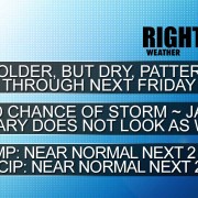
HEADLINES

– Active storm track last 10 days of month – no snow guarantees
– Pattern trends colder late in the month
– Above normal precipitation next two weeks
– Near normal temperature next two weeks

Sorry about the lack of video and graphics in this update. Unfortunately, my workhorse Macbook Pro is on life support after suffering from a common problem that Apple does not consider to be a “known issue”. I’m off to the Apple store to get it looked at.


Long-Range Forecast – December 11

A slow-moving storm will ease away from Southern New England over the weekend, and high pressure will move in from the west. The weather will stay quiet until at least the middle of next week before a disturbance approaches. At this point, we’re not expecting a major impact from it in Southern New England. It looks like rain/snow showers in the midweek.

The overall pattern favors near normal temperatures and a mainly dry stretch through most of the next week. We are expecting the southern branch of the jet stream to become active in late-December, and that could lead to snow and/or rain threats every few days for the last ten days of the month. A white Christmas is not off the table yet!


Long-Range Forecast – December 8

The weather pattern this week will be dominated by the slow-moving storm that will bring strong winds and heavy rain on Tuesday. While the storm will not be nearly as fierce Wednesday and Thursday, it will still be close enough for scattered rain showers on Wednesday, and rain or snow showers on Thursday. In fact, it may not be until midday Saturday before the storm finally moves offshore and high pressure begins to move in from the west. The weekend looks relatively quiet, with highs in the 40s.

Looking ahead to next week, the odds favor fairly quiet weather. A developing system will probably stay far enough south and east of New England that it does not bring substantial snow/rain in the midweek. Overall, it looks like the storm track will be suppressed to the south, and the weather over New England will be warmer than normal, but not as warm as the Midwest. If the midweek storm next week stays south, than there could be a 8-10 day stretch of dry and seasonably mild weather to take us to around December 20-22. There are still signs that it will turn colder and stormier after Christmas through the New Year.

Long-Range Forecast – December 4

All eyes will be on a potential storm early next week. There will not be a lot of cold air around, and, right now, we are favoring rain and wind in Rhode Island and Southeastern Massachusetts Monday night through Tuesday. After that storm passes, there may be an extended stretch of dry weather that lasts through most of mid-December. In addition, it does not look like it will be terribly cold, and will most likely be warmer than normal for this time of the year. It’s not too long before normal highs are only near 40, and normal lows are 25. Odds are most days will be in the 40s between Dec 10-20.

Southern New England 2014-2015 Winter Outlook

November weather can be a pretty good indicator of what kind of winter it will be in Southern New England. If it is this year, then get set for a harsh winter in New England because November was cold, wet, and snowy. While we do not think the upcoming winter will be as cold (relative to normal) as November was, we expect it to be stormy and snowy. It looks like December will actually be a relatively mild month before it turns seasonably cold in January and February.

There is a slight chance that El Niño develops this winter, but even if it does not, there will still likely be enough of an influence on the southern branch of the jet stream to allow for an active storm track across the Southeastern United States. Last winter featured many small winter weather events. We think there is a better chance of bigger storms moving through this winter. As always, precipitation type will be an issue in Southern New England with these storms, so we are not going bonkers with our snow forecast. There is usually around 35″ of snow in the Providence area, so a forecast of 100-150% of normal is for about 35-50″ of snow.

The confidence level is fairly high that it will not be a dry winter. There is less certainty about the temperature, and if the pattern reverts to what it was in November by late in December or early January, than it could be colder than our forecast of slightly warmer than normal conditions for the season.

Long-Range Forecast – December 1

December is off to a very warm start with the temperature soaring into the 60s on Monday. However, the theme of the first week of the month will be a rollercoaster ride, with much colder weather ahead for Tuesday. The temperature may be 30° colder in some spots from noon Monday to noon Tuesday. In fact, there will likely be some snow and mixed precipitation around Tuesday evening before a change to cool rain showers later Tuesday night. The temperature will climb again on Wednesday, and could flirt with 60 again if there is enough sunshine.

It will be seasonably cool and dry late in the workweek. We’re keeping our eye on the potential for chilly rain showers sometime between Saturday and Monday. In a worst-case scenario, all three days will feature some rain. A best-case scenario has the showers holding off through the weekend.

The middle of next week looks dry, with gradually moderating temperatures toward the end of the week. Aside from the light snow/mix possible Tuesday evening, there is not much wintry precipitation in the forecast for the next 10-14 days. Overall, it looks like it will be a relatively wet month, so we’ll have to watch for another storm around the second weekend of December.