Long-Range Forecast – October 30

Even though it looks like the brunt of the storm will stay offshore on Sunday, it’s too early to sound the all clear. Regardless of the storm’s track, it will be a cold start to November. However, the overall pattern in the next couple of weeks should feature more warmer than normal weather than anything else. The pattern also does not look extremely active, with rain threats every 4-6 days, but Nor’easters seem to not be in the cards after this weekend’s threat. See the video for more on the start of November.

Long-Range Forecast – October 27

The buzz has already started about an early season snowstorm in part of the Northeast this weekend. While it’s not impossible, the odds favor a cold shot, with some flakes, but not a blockbuster snowstorm. Before that happens, the relatively mild weather will continue through the workweek until Friday when it falls to seasonable levels. The trick or treat outlook is not super, but it’s not too frightening, either. The temperature will be falling from the 50s into the 40s during the evening. At least it will be dry.

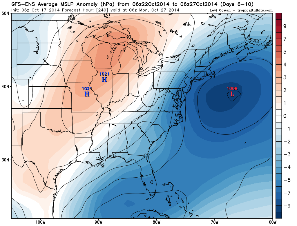
Saturday will become showery and raw, and there is a chance that rain changes to snow Saturday night as a storm develops offshore and cold air is wrapped into the storm. Right now, it looks like there could be enough snow for a dusting to 1″, but it’s tough to say if it will stick because the ground is not frozen, and it will be wet from rain during the day. Of course, if there’s more precipitation than now forecast because of a stronger and slower-moving storm, then the odds of accumulating snow increase. It’s all speculation at this point, and really not worth writing or saying too much about because of the uncertainty with the forecast 5-6 days from now.

in any event, Sunday will be blustery and cold. Highs will only be in the low to mid 40s, and wind chills will be 10-15° colder than the air temperature. It looks dry, and clear skies Sunday night may lead to a widespread frost/freeze scenario that ends the growing season for the part of SNE where it continues.

The cold shot will not last for long, and there should be a decent warm-up next week. In fact, there is not a heck of a lot of very cool weather in the forecast for the first 10 days of November (after this weekend). Mid to late workweek showers are possible next week, but it does not look like a soaking system. Overall, after a rough start, the first half of November looks relatively benign.

Long-Range Forecast – October 23

A very warm stretch in the middle of October has the temperature running a couple of degrees above normal for the month. It looks like we’ll see more relatively warm weather in the middle of next week, and the month is likely to finish 2-3° warmer than normal. Thankfully, there has also been a decent amount of rain, and although the Drought Monitor is keeping most of the area in a moderate drought, but that should change soon based on the recent periodic rain.

The weekend looks fairly quiet with cooler weather on Sunday. There is a slight chance of a shower Saturday night or Sunday morning. Monday through Wednesday will be nice, with a warming trend – especially inland. Highs may reach the low 70s (more than 10° above normal) inland on Wednesday. It will be considerably cooler near the coast with a southwest breeze. A cold front coming through Wednesday night may scare up a few showers, but widespread soaking rain is unlikely. It will not be much cooler on Thursday as fair weather returns. Highs should reach the 60s.

The forecast is tricky for Halloween. There are signs that a strong disturbance will move from central Canada into the Northeast, but the timing of the system is questionable. At this point, rain cannot be ruled out, and if the system moves more quickly than currently forecast, then it could be dry with a chilly breeze for trick or treaters. The best-case scenario is for the system to move slowly and for Thursday’s fine weather to carry over for another day.

There is a decent shot of a legit cold shot during the first weekend of November. The temperature could fall below freezing in Providence for the first time this season. Any cold snap is likely to be short-lived because the pattern looks progressive and variable through the first week of November.

Long-Range Forecast – October 20

An unsettled weather pattern this week will likely be followed by an extended stretch of mainly dry weather from this weekend through most or all of next workweek. There is a slight chance of a cool shot late in the weekend, but that will likely stay north of Southeastern New England, and the temperature will be at or above normal next week. There is a decent chance that the month will end without the temperature getting below 34° at TF Green Airport. That has not happened in October since 2010.

Looking ahead to early November, we will have to keep an eye on any action developing along the Eastern Seaboard. Fast-developing coastal systems are not uncommon in mid-fall with warm water off the coast. Regardless of whether a sizable storm develops, it looks like the jet stream will be active in bringing low pressure systems from west to east across the US. It will likely not be as dry in the first week of November as it looks like it will be next week.

Significant Storm Likely Next Week

A significant long-duration storm appears likely for New England in the middle to end of next workweek. The storm will move from the Great Lakes to the Southern New England coast and intensify on Tuesday into Wednesday. The storm will become cut-off from the jet stream, and will likely not move much through the end of next workweek.

While the exact track of the storm is questionable, there is the potential for several inches of rain in the hardest hit areas. At this point, it seems that Eastern New England will bear the brunt of the storm with the heaviest rain, strongest winds, and possible coastal flooding due to a persistent northeast wind direction for several days.

Even though the event is still several days away, all reliable computer models are predicting that a storm will form off the New England coast and remain nearly stationary for at least a couple of days. See the graphics below for more explanation on the storm’s potential impacts.

Long-Range Forecast – October 16

It looks like a slow-moving weather pattern will continue for the rest of October. Unfortunately, that could mean an extended period of wet and cool weather from the middle to end of next workweek. The models are coming together on a cut-off storm that sits and spins off the New England coast for a few days. If the storm is near Nantucket, then you can bank on wet, breezy, and raw weather in Southeastern New England. Right now, it looks like the main threat is from late Tuesday through Friday.

After the storm drifts out to sea, we should get into several days of dry weather. It does not look like there are any huge cold shots in the forecast except for a quick chilly blast on Sunday into Monday that will keep the daytime temperature in the low to mid 50s, and it will fall into the 30s to low 40s at night. The breeze will stay active, so a frost may not occur near the coast and cities. The pattern for the last week of October is leaning toward warmer than normal weather. See the video for more details.

Long-Range Forecast – October 13

So far, October has gone according to the book. The temperature is within a degree of normal through nearly two weeks, and there has been a reasonable amount of rain. The weather will get active later this week, and there is potential for more action in the following week, too. This week’s moderate to heavy rain looks like a lock on Thursday. Next week, the forecast is uncertain because the storm system may develop far enough offshore that it does not have an impact in Southern New England, and that would mean an extended dry stretch in this slow-moving weather pattern.

It will be breezy and mild through this workweek. Patchy dense fog is possible at night. The days will be dry or mainly dry through Wednesday. Thursday, however, looks wet – especially in the afternoon and evening. Moderate to heavy showers, and possibly thunderstorms, will develop ahead of a cold front that is slowly moving east through the Eastern United States.

The weather will improve quickly on Friday, and the weekend looks fairly quiet. Saturday will be seasonably warm with some late-day clouds. Scattered showers are possible as cooler air arrives with a disturbance on Sunday. It does not look like a washout, and if the timing changes slightly, the day will be partly sunny and seasonable.

We are leaning to most of the action next week being offshore as high pressure moves in from Eastern Canada. Eventually, in this pattern, something could develop over the Southeast and move up the Eastern Seaboard bringing a wind-driven chilly rain. That’s possible in the last five days or so of October.

Long-Range Forecast – October 9

The hallmark of the next 10-15 days will be a slow-moving weather pattern. After a storm scoots out to sea south of Southern New England bringing chilly showers on Saturday, there will be three mainly dry days into the middle of next week. Eventually, another storm system will move into the Northeast and showers and thunderstorms are possibly Wednesday and/or Thursday of next week. The rain could be heavy at times depending on the exact track of the storm.

More dry weather is likely at the end of next workweek, and through next weekend. We’re still keeping our eye out for a brief cold shot around October 20. In this pattern, we also need to watch for storms to develop near the Southeastern United States and move north. There are signs that could happen in the last ten days of October.

Much of Southeastern New England remains in a moderate drought, but that may be short-lived with a couple of rain events ahead, and already a decent amount of rain so far this month.

Long-Range Forecast – October 6

October is off to a rainier start than September, and that is good news for drought-parched Southern New England. There is more rain in the forecast for the middle of this week before about 48 hours of dry weather from Wednesday afternoon into Friday. Another front will head for Southern New England and bring more showers on Friday. Right now, it looks like that front will settle south of our area for most of the Columbus Day weekend. I’m a little leery of the front drifting north or a wave of low pressure forming along the front and delivering another round of showers sometime between Saturday and Monday. It will be a seasonably cool weekend, with highs in the low 60s.

There is a decent amount of uncertainty with next week’s forecast. The pattern looks fairly slow-moving, and it’s unclear how far east a storm system will get in the middle of the week. The latest indications are that it may be west of Southern New England for a while, but that is just a trend. There will also be a disturbance in the Atlantic Ocean that could bear watching if it drifts northwest to off the Carolina coast. Once again, it looks like the best chance of showers is in the midweek.

Both the GFS and European model are hinting at a cold shot around October 20. It does not look like it will last long, but it may be the one that puts an end to the growing season in most of Southern New England. It’s that time of the year!

Long-Range Forecast – October 2

It looks like we’ll continue to come out of a dry stretch of weather with rain or shower threats every few days for the next couple of weeks. Showers are likely on Saturday, primarily in the afternoon and evening. Sunday through Tuesday looks dry before another front brings rain in the middle of next week. There may be a third front in the next 10 days coming through on Columbus Day weekend. I’m not as convinced that we’ll see steady rain from that one. We’ll have to keep an eye on the tropical system in the Eastern Pacific Ocean, and where it’s remnants move through the Southwest US.

The overall pattern is not super exciting temperature-wise. Most days will be near normal, and nights will probably average above normal in the next two weeks. It does not look like we have any early blasts of very cold weather heading our way. The tropics also continue looking sleep in the Atlantic and Gulf of Mexico.