Long-Range Forecast – July 30

July is ending with the warmest weather of the summer in Southeastern New England. The high temperature will continue flirting with 90° through this weekend into early next week. It’s certainly not an extremely hot stretch for our area, but it’s the warmest we’ve seen so far this year. The weather will be dry through the weekend into early next week. Humidity will fall by midday Friday, and it will gradually return over the weekend.

The heat will break with unsettled weather in the middle to end of next workweek. The warm pattern will flip to a cooler one from around August 5-15. It looks like there will be high pressure over Eastern Canada, and there may be some unsettled weather developing along the Eastern Seaboard. While it’s a dry start to the next two weeks, there is a pretty good chance that precipitation will be near or above normal in the second week. The pattern through mid-August does not look favorable for much, if any, 90° heat.

Long-Range Forecast – July 27

July is running about 0.5° above normal in the Providence area with a few days to go. A hot finish should be enough to make it more than 1° warmer than normal for the month. Unless it gets hit with a heavy thunderstorm in the next few days, TF Green Airport will likely come in with slightly below normal precipitation for the month. Of course, precipitation totals over a large area in the summer can vary greatly. For instance, parts of Portsmouth and Tiverton received more than a month’s worth of rain in just a few hours this morning. The souther part of RI was still in a drought as of last week, but today’s rain certainly helped.

We expect at least 6 of the next 9 days to be 90° or hotter inland. It’s possible a few spots could reach 90° for 9 straight days beginning on Tuesday. The hottest weather this week looks like it will come on Wednesday and Thursday. Highs will be in the low to mid 90s with heat indices near or above 100° because of the humidity.

The heat will not have as much humidity this weekend into early next week, but by the end of the hot stretch, the humidity is likely to become oppressive again. After the heat breaks late next week, we could be in for an extended stretch of relatively cool and dry weather. That’s good news for anyone who detests hot/humid weather, and it also will help our bank accounts as we save some money on air conditioning. Rainfall-wise, it looks like the pattern could become active along the Eastern Seaboard sometime after August 6 through the middle of the month. In the meantime, scattered t-storms are possible Tuesday, Thursday, and Wed-Thu of next week.

Long-Range Forecast – July 24

The temperature is running slightly above normal in July with one week to go. Although this weekend will be somewhat cool and unsettled, the overall trend in the next seven days is for warmer weather to return to Southeastern New England. In fact, the hottest weather of the summer so far will likely arrive in the middle of next week. There could be a day or two in the mid 90s inland. It will be humid, too, so overnight low temperatures will probably not get below 70.

The relatively warm weather will continue into the first few days of August, but it will probably not be as hot as the middle of next week. It looks like a front may stall near the Eastern Seaboard in early August, and that could be the impetus for showers and thunderstorms. It’s also an area to watch for tropical cyclone development. Some models are hinting at something forming near the East Coast within the first week of August. It has been dry for the past week, but the next couple of weeks should feature near normal precipitation as the pattern gets more active. See the video for more.

Long-Range Forecast – July 21

We are in the midst of the hottest stretch of the summer to date. A few spots may see a third straight 90° day on Tuesday, but most will not have a heat wave. The hotter weather is nothing out of the ordinary for what’s typically the warmest time of the year. The normal high is in the mid 80s, so reaching 90° is less than 10° above normal – not that big of a deal. We were not expecting a lot of extreme heat this summer, and it looks like that pattern will hold through the end of July into early August.

Drier and cooler weather is on the way for late in the workweek into the weekend. The weather for the Taylor Swift concerts will be pretty good. There’s a slight chance of pop-up showers between 3-7 pm on Fri/Sat, but odds are they’ll stay away, and it will be delightful in the evening without much humidity and comfortably mild temperatures.

A front may bring showers/storms late in the weekend. It’s still early but the timing look like Sunday afternoon or night – which is a big difference if you have outdoor plans in the afternoon. We’ll keep you posted.

The overall pattern favors cold fronts moving through the Northeast every few days at the end of the month and in early August. That means we will not get stuck with any particular weather for too long. Extended hot/cool stretches are unlikely. See the video for more.

Long-Range Forecast – July 17

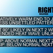
It’s hard to believe that meteorological summer is already more than half-finished. So far, there has been no extreme heat in Southeastern New England. Providence and Boston are still waiting on the first 90° day of the year. In fact, Providence has not been warmer than 88°. The last time it failed to reach 89° this far into the year in Providence was in 1932. The high temperature for that entire year was just 88°. There is a better than 50% chance that the temperature reaches 90° in the next couple of weeks. Climatologically, this is the warmest time of the year. The weather pattern looks relatively warm for the last two weeks of the month.

The first shot at 90° in on Sunday if clouds burn off to hazy sunshine with a southwest wind. The air aloft will be warm enough to support 90°, it’s just a matter of getting several hours of sunshine and keeping the wind from shifting to the south or southeast at TF Green. It will be quite humid on Sunday, and will likely feel like the 90s regardless of whether the temperature gets that high.

Showers and storms are possible on Monday as a cold front moves through. It will not be cooler behind the front, and there is another shot at 90° in the middle of next week.

Mid-summer is a good time to check in our summer forecast. So far, it is going pretty well. Here are the headlines published in early June.
2015-06-01-summer-headlines
It has certainly not been extremely hot. We thought it would be a bit muggier than it has been, but at least half the days so far this summer have featured above normal low temperatures – a sign that there is humidity in the air. There was above normal rain in June, and so far July is running near normal in Providence, and above normal near the coast. There has not been much tropical development so far, but we’re still favoring storms that form not too far from the Eastern Seaboard. The temperature was 1.6° below normal in June, and is slightly above normal in July.

There may not be too much rain in the last two weeks of July. There will be a few showers around on Saturday, but it will not be a washout. Then there is the Monday thunderstorm threat. After that, there will be a dry stretch that may last through next weekend. We’ll be watching for a disturbance early next weekend, but it may stay northwest of our area. If you have vacation in the next week or two, you can expect some decent beach weather with typical Dog Days conditions most of next week and, at least, part of the following week.

Abundant rainfall for most in the Northeast in the alst month

Abundant rainfall for most in the Northeast in the alst month

610prcp.new 610temp.new 814prcp.new 814temp.new

CVSv2 - warmer than normal last two weeks of July

CVSv2 – warmer than normal last two weeks of July

EPS precipitation - dry to slightly below normal precipitation next 10 days

EPS precipitation – dry to slightly below normal precipitation next 10 days


GEFS temperature anomaly - mostly warmer than normal

GEFS temperature anomaly – mostly warmer than normal

2015-07-17-headlines

Long-Range Forecast – July 2

June is in the books as wet and a bit cool in Southeastern New England. July began with heavy thunderstorms, and there has yet to be a 90° day in the Providence area this year. In fact, 87° is the highest temperature to date at TF Green Airport. It will not be reach 88° on the 4th of July. Instead, it looks like it will be on the cool side with some clouds around. A passing shower cannot be ruled out as a weak disturbance passes out to sea south of Southern New England. Highs will be in the 70s, but the temperature could fall into the 60s with thicker clouds and a northeast breeze in the afternoon.

The weather will be summery, but not too hot, Sunday into early next week. The generally active weather pattern will return in the middle to late part of next week, and looking way down the road, it does not appear that there is a significant pattern change ahead. It’s possible we’ll make it into late July without a 90° day. There will be periodic rain chances from the middle of next week through the following week. The lion’s share of the rain may be south and west of our area, but there will most likely be at least a normal amount of rain in the next two weeks.