Long-Range Forecast – May 14

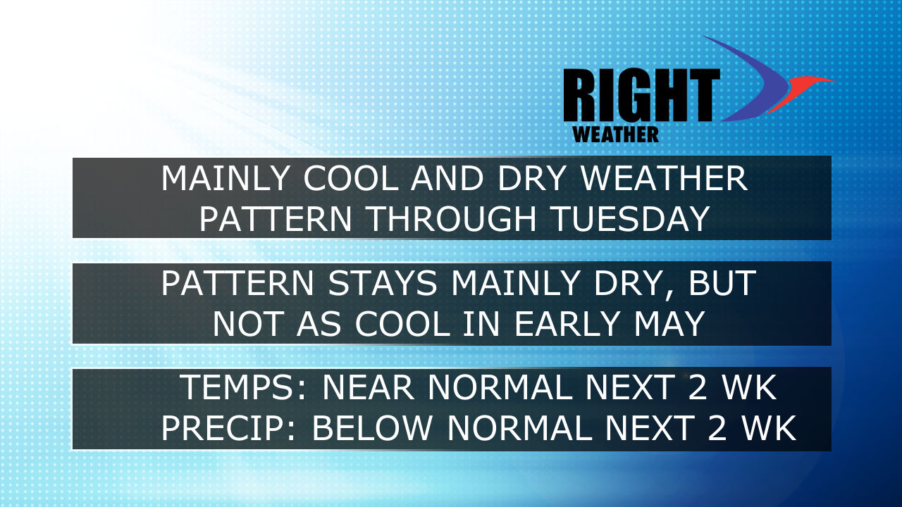
It will not be quite as dry in the next week or two as it has been in the past three weeks, but it does not look like a very wet pattern, either. The total rainfall will likely be below normal. The best chances for rain are Saturday, Tuesday, and late in the Memorial Day weekend. Saturday and Tuesday look like showers, with Tuesday having the best chance of 0.25″ of rain. That’s not very much.

Temperature-wise, it may get warm on Sunday, but the wind will shift to the northeast on Monday, and it looks seasonable or a bit cool for a good chunk of next workweek. The temperature will likely bounce back to warmer than normal over the Memorial Day weekend.

Long-Range Forecast – May 11

It has been downright summer-like for the past couple of days away from the coast. At this time of the year, the coast is much cooler and there’s always fog flirting when there is a southwest breeze. We’ll have one more warm and muggy day before cooler weather arrives Tuesday night. The weather looks pleasant from Wednesday through Friday. A weak disturbance could trigger a few showers on Saturday. It bears watching. We could definitely use the rain, but nobody wants it on the weekend. Right now, it does not look like anything close to a washout. Seasonably cool weather is likely Sunday, with highs in the mid to upper 60s.

Next week looks fairly quiet. It will not be very warm and muggy, but it should not be too cool, either. There are no organized soaking rain storms on the radar for the next 7-10 days. Further down the road, it looks like the warmth and humidity will return around the Memorial Day weekend. Overall, May is expected to be warmer than normal, with well below normal precipitation.

Long-Range Forecast – May 7

We’re definitely in a nice groove weather-wise in Southern New England. It will stay fair through the weekend, with the warmer days on Friday and Sunday. Muggy weather is likely early next week as a front slowly approaches from the west. The system pictured below has a 90% chance of becoming Sub-tropical Storm Ana in the next 48 hours. It will meander near the SE US for a bit, and may get drawn north early next week. Right now, it does not look like it will have much punch or moisture left when it gets here ahead of the front, but it bears watching for enhanced rainfall if it holds together.

90% chance this becomes Sub-tropical Storm Ana

90% chance this becomes Sub-tropical Storm Ana

The weather will turn cooler and likely be dry late next workweek into next weekend. The outlook for late next weekend through the middle of the following week is for mainly dry, but warmer weather to return. Check out the video for more.

Long-Range Forecast – May 4

The temperature soared into the 80s away from the coast on Monday. I have yet to hear anyone complain about the heat, and that’s probably due to the kind of winter we just endured. It looks like the relatively warm spring weather is here to stay through the Mother’s Day weekend into early next week. Aside from a few stray showers on Tuesday, the pattern looks dry through the end of the week. Lows will be in the 50s for several days between Tuesday and next Monday. Highs will routinely reach the 70s inland, and it will be cooler near the coast most days because of a southwest breeze.

A cold front in the middle to end of next work week could bring a cool-down into the weekend of May 15-16, but it does not look terribly chilly for mid-May. In fact, signs are that their could be a rather pleasant area of high pressure that meanders out of central Canada and sets up shop in the Northeast.

It has been a dry spring, and that will not change much in the next couple of weeks. One potential fly in the ointment is a storm that may develop off the Carolina coast. It it becomes and organized system and gets drawn north by the jet stream, then a soaking rain is possible next week. Right now, that is not the likely scenario.

Long-Range Forecast – April 30

April will go in the books as slightly cooler than normal with about 50% of the normal precipitation in Southeastern New England. The relatively dry month alleviated any flooding concerns in Rhode Island and Southeastern Massachusetts after the snowy winter.

May will begin with a very cool day on Friday, but most of the first half of the month will feature near to above normal temperatures in the Northeast. It looks warm inland early next week before a front threatens with showers and thunderstorms on Tuesday. The rest of the workweek looks dry and seasonably warm.

There are no major storms in the forecast for the next 10-14 days. The early outlook for May is for drier than normal weather in the first half of the month. There may be another surge of relatively warm weather late in Mother’s Day weekend and early the following week.

Long-Range Forecast – April 27

Overall, the weather pattern looks rather quiet for the next couple of weeks. There is a close-call with a storm late this workweek, but it looks like it will stay far enough offshore to not bring steady rain and strong winds. Friday will be unseasonably cool and breezy to windy, but not a washout.

The weather will turn around this weekend, and a mild Sunday is likely. Highs will be in the 60s on Sunday. It may reach the 70s inland for a couple of days early next week. After that, it is not likely that there will be any major storms late next week into the Mother’s Day weekend. That does not mean it will be dry all the time, but the disturbances coming through do not look particularly strong.

The jet stream is fairly amplified this week, but the storm track will keep steady rain away. Next week, it looks like a more zonal (west to east) flow that will keep the temperature near to slightly above normal, and precipitation will likely be below normal.

Long-Range Forecast – April 23

The temperature barely reached 50° on Thursday in the Providence area. That’s more than 10° cooler than normal for the date. There were also some snow showers in Connecticut! So, after a mild stretch in mid-April, we are back into a cool pattern. The temperature will be at or below normal for the next week or so. It will be a mainly dry pattern in the next week to 10 days. Just a stray shower is possible on Friday, and the weekend will likely be dry.

A disturbance moving through early next week will likely trigger showers and possibly a thunderstorm on Monday. It may be close enough for a few more showers on Tuesday. Highs will be in the 50s from Friday through Tuesday.

The middle of next week should be closer to normal for late April and early May. Right now, it does not look like there are any big storms coming down the pike, and it may be mainly dry through most of the first week of May. Cold fronts could bring scattered showers from time to time. The pattern looks fairly progressive.

Headlines

  • Mainly dry pattern next two weeks
  • Cooler than normal for the next 6 days. Near to slightly warmer than normal after that.
  • Still don’t see a big pattern change that would lead to an extended stretch of warm weather.
  • A extended stretch of cool/raw weather is also unlikely in this pattern. The next 6 days, while a bit cool, will not feature an onshore breeze that makes it raw/damp at this time of the year.

2015-04-23-Headlines

Long-Range Forecast – April 20

Monday was the unsettled and cooler weather that we mentioned in the Long-Range Forecast on April 9. And, as we mentioned during last week’s Long-Range Forecast, there will be a cut-off area of low pressure hanging around the Northeast at the end of April. Initially, this cut-off low will mean seasonably cool and mainly dry weather late this workweek through the weekend. One potential fly in the ointment is a storm moving through the Mid-Atlantic this weekend. Right now, it looks like it will stay south of Southern New England, but it bears watching.

As we get farther into the long-range, there is the potential for a storm to form near the Northeast coast. I do not expect that to happen until sometime between April 29-May 4, if at all. The large-scale pattern is not favorable for an extended warm-up through early May.

Long-Range Forecast – April 16

I hate to put it bluntly, but don’t get used to the gorgeous weather that we have enjoyed for the past couple of days. While we will have a nice weekend, most of the next two weeks looks somewhat unsettled in New England. Showers are possible Friday, followed by a dry weekend. Early next week, a soaking rain is likely from a storm system pulling out of the Southeastern United States. It’ll be a close call for the Boston Marathon runners, and some of the later finishers may get wet. The rain will arrive in RI and SE MA by midday, and it will be steady by late in the afternoon. Heavy rain and possibly thunderstorms roll through Monday night. Look for a break in the action Tuesday PM through Wednesday before rain threatens again later in the workweek. A cut-off area of low pressure is unlikely to bring soaking rain, but showers may be in the forecast for several straight days. As for a warm-up, don’t expect it with a cool pool of air over the Northeast in late April.

Long-Range Forecast – April 13

Relatively mild weather will continue through the midweek before a general cooling trend happens in the late workweek into early next week. There is nothing terribly cold or very warm in the forecast for the next couple of weeks. The best chances for rain this week are Tuesday (spotty AM showers), Friday (few spotty showers possible), and Saturday PM (best chance of 0.25″ of rain). None of the systems look like washouts.

The weather looks dry and seasonably cool Sunday through Monday. Boston Marathoners should have decent running conditions. Showers are possible again in the middle of next week. The overall pattern for late-April looks near to colder than normal. It also looks like there could be some rainy systems heading for the Northeast near the end of the month. It doesn’t look awful, but don’t expect a huge, extended warm-up in the next couple of weeks.